


Hurricane Erin 2025 has emerged as one of the most significant weather events of the Atlantic hurricane season, marking a historic milestone as the first major hurricane to form this year. This powerful storm system has captivated meteorologists and residents across the Caribbean and Eastern United States with its unprecedented rapid intensification and record-breaking characteristics.
As Hurricane Erin 2025 continues its path through Atlantic waters, understanding its development, trajectory, and potential impacts becomes crucial for coastal communities and weather enthusiasts alike. The storm’s remarkable transformation from a tropical disturbance to a Category 5 hurricane in just days has placed it among the fastest intensifying storms in recorded Atlantic history, making Hurricane Erin 2025 a weather phenomenon worthy of comprehensive analysis and continuous monitoring.


Understanding Hurricane Erin 2025: Formation and Development
Hurricane Erin 2025 began its journey as a tropical disturbance in the Atlantic Ocean before rapidly organizing into a tropical storm. The storm’s formation followed typical patterns observed during peak Atlantic hurricane season, which runs from August through October. What sets Hurricane Erin apart from other storms this season is its extraordinary rate of intensification, with wind speeds increasing by at least 35 mph within a 24-hour period.
The atmospheric conditions that contributed to Hurricane Erin’s development included exceptionally warm sea surface temperatures, low wind shear, and favorable upper-level divergence patterns. These optimal conditions allowed the storm to tap into the abundant energy available in the Atlantic’s warm waters, fueling its rapid strengthening process.
Meteorologists have noted that Hurricane Erin 2025 represents the fourth consecutive year that the Atlantic basin has produced a Category 5 hurricane, highlighting concerning trends in storm intensity related to climate change and warming ocean temperatures. The storm’s development pattern mirrors that of previous major hurricanes, yet its rapid intensification rate places it in an elite category of Atlantic storms.
Rapid Intensification: A Defining Characteristic
The rapid intensification of Hurricane Erin 2025 has become one of its most notable features, with the storm achieving major hurricane status within an remarkably short timeframe. This rapid strengthening process occurs when a tropical cyclone’s maximum sustained winds increase by at least 35 mph in a 24-hour period, a phenomenon that has become increasingly common in recent Atlantic hurricane seasons.
Several factors contributed to Hurricane Erin’s explosive development, including the presence of a well-defined eye wall, minimal wind shear throughout the atmospheric column, and sea surface temperatures well above the threshold required for tropical cyclone formation and maintenance. The storm’s compact structure initially allowed for efficient energy transfer from the ocean to the atmosphere, creating ideal conditions for rapid intensification.
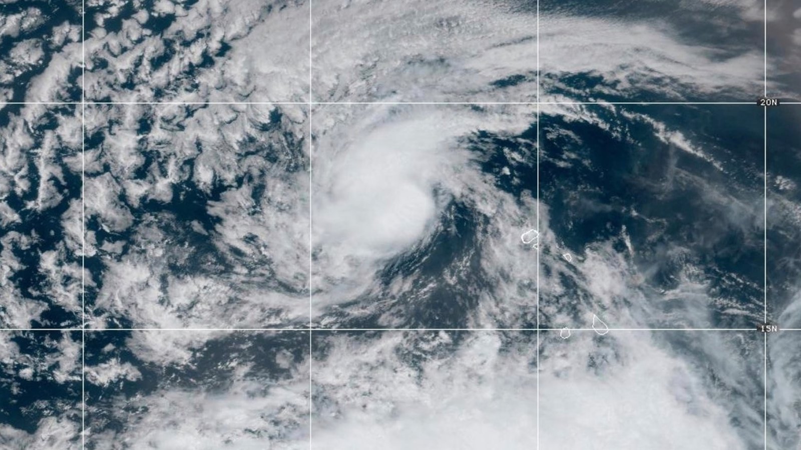
Hurricane Erin 2025 Path and Trajectory Analysis
Current Position and Movement
As of the latest updates, Hurricane Erin 2025 is tracking through the Atlantic Ocean, following a path that takes it north of the Lesser Antilles and Puerto Rico. The storm’s current trajectory suggests it will continue on a north-northeastward path, potentially affecting areas of the Caribbean before curving away from the United States mainland.
The Hurricane Erin 2025 path has been carefully monitored by the National Hurricane Center, with computer forecast models showing remarkable consistency in predicting the storm’s general direction of movement. Current projections indicate that the hurricane will pass north of Puerto Rico and the Greater Antilles before beginning a gradual turn toward the northeast as it encounters steering currents in the mid-latitude atmosphere.
Forecast Models and Predictions
Multiple forecast models, including the Global Forecast System (GFS) and European Centre for Medium-Range Weather Forecasts (ECMWF), have provided valuable insights into Hurricane Erin’s expected path. These sophisticated computer models utilize current atmospheric data to project the storm’s future position, intensity, and potential impacts on populated areas.
The spaghetti models for Hurricane Erin show a general consensus among different forecast systems, with most indicating that the storm will avoid a direct landfall on the United States mainland. However, meteorologists continue to emphasize the importance of monitoring the storm’s progress, as even minor changes in atmospheric conditions can significantly alter a hurricane’s path.
Impact Assessment: Caribbean and Atlantic Regions
Caribbean Islands Alert Status
The Caribbean islands have been placed under various levels of alert as Hurricane Erin 2025 approaches the region. While the storm is expected to pass north of most major population centers, its large size and intense winds pose significant risks to maritime activities and coastal areas throughout the Lesser and Greater Antilles.
Heavy rainfall associated with Hurricane Erin’s outer bands threatens to produce flooding conditions across several Caribbean territories. Storm surge, though not expected to reach catastrophic levels due to the storm’s projected path, remains a concern for low-lying coastal areas and vulnerable communities throughout the region.
Local authorities across the Caribbean have activated emergency management protocols, ensuring that residents have access to updated information about Hurricane Erin’s progress and potential impacts. Evacuation plans have been reviewed, and emergency shelters have been prepared in areas that might experience direct effects from the storm’s passage.
United States East Coast Considerations
Although Hurricane Erin 2025 is not currently forecast to make landfall along the United States East Coast, the storm’s influence will still be felt across the region through dangerous surf conditions, rip currents, and elevated tides. Coastal areas from Florida to Maine are expected to experience increased wave heights and hazardous beach conditions as the hurricane passes offshore.
The Atlantic hurricane season’s first major storm serves as a crucial reminder for East Coast residents to review their hurricane preparedness plans and emergency supplies. Even storms that remain offshore can produce life-threatening conditions, including dangerous rip currents that can persist for several days after the storm’s closest approach.
Meteorologists anticipate that Hurricane Erin will generate swells that propagate hundreds of miles away from the storm’s center, affecting beaches and coastal waters well in advance of the hurricane’s arrival in any particular area. These conditions typically develop 2-3 days before the storm’s closest approach and can persist for several days afterward.
Record-Breaking Characteristics of Hurricane Erin 2025
Category 5 Status Achievement
Hurricane Erin 2025 achieved Category 5 status on the Saffir-Simpson Hurricane Wind Scale, joining an exclusive group of only 43 Atlantic hurricanes on record to reach this maximum intensity classification. The storm’s peak winds exceeded 157 mph, placing it among the most powerful hurricanes ever observed in the Atlantic basin.
The achievement of Category 5 intensity by Hurricane Erin is particularly noteworthy given the relatively early point in the hurricane season when this occurred. Historically, the strongest Atlantic hurricanes tend to develop during the peak months of September and October, making Hurricane Erin’s mid-August intensification an unusual meteorological event.
This record-breaking intensification adds Hurricane Erin to a growing list of extremely powerful storms that have developed in the Atlantic in recent years, including Hurricane Dorian (2019), Hurricane Lorenzo (2019), and Hurricane Mitch (1998). The increasing frequency of Category 5 hurricanes has raised important questions about changing climate patterns and their influence on tropical cyclone development.
Historical Significance and Comparisons
The rapid intensification rate of Hurricane Erin 2025 places it among the fastest-strengthening storms in Atlantic hurricane history. This achievement is measured by the rate at which the storm’s central pressure dropped and its maximum sustained winds increased over a specific time period.
When compared to other rapidly intensifying hurricanes such as Hurricane Wilma (2005) and Hurricane Patricia (2015) in the Eastern Pacific, Hurricane Erin’s development rate demonstrates the potential for modern storms to achieve extreme intensity in very short timeframes. This trend has significant implications for hurricane forecasting and emergency management planning.
The historical context of Hurricane Erin’s development reveals patterns consistent with climate change projections, which suggest that while the total number of hurricanes may not necessarily increase, the proportion of very intense storms is likely to grow as ocean temperatures continue to rise and atmospheric conditions become more conducive to rapid intensification.
Meteorological Analysis and Science Behind the Storm

Atmospheric Conditions Favoring Development
The development of Hurricane Erin 2025 was facilitated by a combination of atmospheric and oceanic conditions that created an ideal environment for tropical cyclone formation and intensification. Sea surface temperatures in the Atlantic were well above the 26.5°C (80°F) threshold required for hurricane development, providing abundant energy for the storm’s growth.
Low wind shear throughout the atmospheric column allowed Hurricane Erin to maintain its structure and continue strengthening without disruption from conflicting wind patterns. This lack of wind shear is crucial for hurricane development, as it prevents the storm’s circulation from being torn apart by opposing winds at different altitudes.
Upper-level divergence patterns created by the positioning of high-pressure systems and the subtropical ridge provided additional support for the storm’s intensification process. These patterns enhanced the storm’s ability to ventilate air from its core, promoting continued development and strengthening.
Eyewall Replacement Cycle
During its period of peak intensity, Hurricane Erin 2025 underwent an eyewall replacement cycle, a natural process that occurs in very intense hurricanes when the storm’s structure becomes so well-developed that it begins to reorganize itself. This process typically results in temporary fluctuations in the storm’s intensity as the inner eyewall is replaced by an outer ring of convection.
The eyewall replacement cycle in Hurricane Erin was closely monitored by hurricane specialists using advanced satellite imagery and aircraft reconnaissance data. This process is significant because it can cause temporary weakening followed by potential re-intensification, making accurate intensity forecasting particularly challenging during these periods.
Understanding these complex meteorological processes is crucial for improving hurricane intensity forecasting and providing more accurate warnings to potentially affected populations. The detailed observations of Hurricane Erin’s eyewall replacement cycle will contribute valuable data to ongoing research into tropical cyclone dynamics.
Safety Measures and Emergency Preparedness
Current Advisory Information
The National Hurricane Center continues to issue regular updates and advisories for Hurricane Erin 2025, providing crucial information about the storm’s position, intensity, and projected path. These advisories include specific recommendations for maritime interests, coastal communities, and travelers in potentially affected areas.
Current hurricane warnings and watches have been established for various Caribbean territories based on the storm’s projected path and intensity. Residents in these areas are advised to complete all preparations immediately and follow guidance from local emergency management officials.
The dynamic nature of Hurricane Erin’s forecast requires continuous monitoring of official updates, as changes in the storm’s path or intensity can significantly alter the risk level for different areas. Emergency management agencies emphasize the importance of staying informed through official channels and avoiding reliance on social media for critical safety information.
Preparation Guidelines for Affected Areas
Communities within the potential impact zone of Hurricane Erin 2025 should ensure they have adequate emergency supplies, including water, non-perishable food, medications, flashlights, batteries, and battery-powered or hand-crank radios. Emergency kits should contain supplies for at least 72 hours, though longer periods may be necessary in areas where recovery efforts might be delayed.
Storm surge preparations are particularly important for coastal residents, even in areas where Hurricane Erin is not expected to make direct landfall. Storm surge can occur well in advance of a hurricane’s arrival and can penetrate significant distances inland, making evacuation from vulnerable areas critical for life safety.
Residents should review their hurricane evacuation plans and ensure they have multiple routes identified in case primary evacuation routes become impassable. Fuel tanks should be filled, and important documents should be secured in waterproof containers or stored in safe locations away from potential flood zones.
Climate Change Implications and Future Trends
Warming Ocean Temperatures Impact
The development of Hurricane Erin 2025 occurs within the context of steadily rising ocean temperatures throughout the Atlantic basin, a trend that has significant implications for future hurricane activity. Warmer ocean waters provide more energy for tropical cyclone development and can contribute to more rapid intensification rates.
Research has shown that Atlantic hurricane intensity has increased in recent decades, with a greater proportion of storms reaching major hurricane status (Category 3, 4, or 5). Hurricane Erin’s rapid intensification to Category 5 status exemplifies this trend and highlights the potential for future storms to achieve extreme intensity more frequently.
The warming climate also affects atmospheric circulation patterns that influence hurricane tracks and development regions, potentially altering the traditional patterns of Atlantic hurricane activity. These changes have important implications for long-term coastal planning and emergency management strategies.
Research and Scientific Advancements
The intense study of Hurricane Erin 2025 provides valuable data for advancing our understanding of rapid intensification processes and extreme hurricane development. Modern satellite technology, aircraft reconnaissance, and computer modeling systems allow researchers to observe and analyze storm processes with unprecedented detail.
Advances in hurricane forecasting have improved significantly in recent decades, with track forecasts showing particular improvement. However, intensity forecasting remains more challenging, especially for rapidly intensifying storms like Hurricane Erin, making continued research and development in this area crucial for public safety.
The comprehensive data collected during Hurricane Erin’s lifecycle will contribute to ongoing climate research and help scientists better understand the relationship between global climate change and tropical cyclone activity. This information is essential for developing more accurate long-term projections of hurricane risk and intensity.
Economic and Social Impacts
Maritime and Aviation Disruptions
Hurricane Erin 2025 has caused significant disruptions to maritime and aviation operations throughout the Atlantic region, with numerous flights canceled or rerouted to avoid the storm’s path. Shipping routes have been altered to ensure vessel safety, resulting in delays for cargo deliveries and passenger services.
The economic impact of Hurricane Erin extends beyond direct damage to include lost productivity, increased transportation costs, and disruptions to supply chains serving the Caribbean and Eastern United States. Tourism, a critical industry for many Caribbean nations, faces particular challenges as travelers cancel or postpone trips due to safety concerns.
Commercial fishing operations have been suspended in areas affected by Hurricane Erin’s passage, impacting both individual fishing families and the broader seafood industry. Recovery of normal operations may take several days or weeks depending on the extent of damage to vessels, equipment, and shoreline facilities.
Insurance and Risk Management Considerations
The development of Hurricane Erin 2025 as a Category 5 storm has implications for insurance markets and risk management strategies throughout the Atlantic region. Insurance companies closely monitor major hurricanes to assess potential claims exposure and adjust future premium calculations.
Risk assessment models used by insurance companies, government agencies, and emergency managers must account for trends toward more rapidly intensifying storms like Hurricane Erin. These models help determine evacuation priorities, resource allocation, and long-term mitigation investments.
The increasing frequency of intense Atlantic hurricanes raises important questions about the sustainability of coastal development patterns and the adequacy of current building codes and zoning regulations in hurricane-prone areas.
Technology and Monitoring Systems
Satellite Surveillance and Data Collection
Advanced satellite technology plays a crucial role in monitoring Hurricane Erin 2025 and providing the detailed observations necessary for accurate forecasting. Geostationary and polar-orbiting satellites equipped with sophisticated sensors capture continuous images and atmospheric data that help meteorologists track the storm’s development.
Microwave satellite imagery penetrates through clouds to reveal the internal structure of Hurricane Erin, including the development and maintenance of its eye wall and the organization of spiral bands. This technology provides insights into the storm’s intensity and structure that are not visible in traditional visible or infrared satellite imagery.
Advanced scatterometer data from satellites helps meteorologists analyze surface wind patterns across Hurricane Erin’s circulation, providing crucial information for determining the storm’s size, intensity, and wind distribution. This data is essential for generating accurate storm surge forecasts and assessing potential impacts.
Hurricane Hunter Aircraft Operations
Hurricane Hunter aircraft operated by the National Oceanic and Atmospheric Administration (NOAA) and the Air Force Reserve have conducted multiple reconnaissance missions into Hurricane Erin 2025, collecting invaluable data about the storm’s structure, intensity, and environmental conditions.
These specialized aircraft deploy dropsondes—instrumented packages that are released from the aircraft and transmit atmospheric data as they fall through the storm. This direct sampling of Hurricane Erin’s environment provides ground-truth data that cannot be obtained through remote sensing methods alone.
The flight-level observations collected by Hurricane Hunter aircraft help meteorologists validate and improve satellite-based intensity estimates, leading to more accurate forecasts of Hurricane Erin’s strength and behavior. This data is immediately transmitted to the National Hurricane Center and incorporated into forecast models.
Regional Preparedness and Response Coordination
International Cooperation Efforts
The response to Hurricane Erin 2025 demonstrates the importance of international cooperation in hurricane monitoring and emergency response. Caribbean nations work closely with the United States National Hurricane Center and other international meteorological services to share data and coordinate preparedness efforts.
Regional emergency management organizations facilitate the sharing of resources and expertise among Caribbean territories, ensuring that smaller islands have access to the technical capabilities and emergency supplies needed to prepare for and respond to major hurricanes like Hurricane Erin.
Cross-border coordination becomes particularly important when hurricanes threaten multiple jurisdictions, requiring synchronized evacuation plans, resource sharing agreements, and post-storm recovery assistance programs.
Community Resilience Building
The approach of Hurricane Erin 2025 highlights the importance of community-level resilience building and disaster preparedness education. Communities that have invested in hurricane preparedness education and infrastructure improvements are better positioned to withstand major storm impacts.
Social vulnerability factors such as poverty, age, disability, and language barriers significantly influence a community’s ability to prepare for and recover from hurricanes. Emergency managers must account for these factors when developing evacuation plans and resource distribution strategies.
Building long-term resilience to hurricanes like Hurricane Erin requires sustained investment in infrastructure improvements, public education, and social support systems that address the underlying factors that make communities vulnerable to storm impacts.
Conclusion
Hurricane Erin 2025 stands as a remarkable example of the power and unpredictability of Atlantic hurricanes, demonstrating both the advances in meteorological science and the ongoing challenges posed by rapidly intensifying storms. As this historic Category 5 hurricane continues its journey through Atlantic waters, it serves as a powerful reminder of the importance of preparedness, scientific monitoring, and climate adaptation strategies.
The unprecedented rapid intensification of Hurricane Erin provides valuable lessons for emergency managers, researchers, and coastal communities about the evolving nature of hurricane threats in a warming climate. The storm’s development pattern and record-breaking characteristics will undoubtedly influence future hurricane research and forecasting methodologies.
As we continue to monitor Hurricane Erin 2025 and assess its impacts, it becomes clear that staying informed through official weather sources, maintaining emergency preparedness, and supporting continued advances in hurricane science are essential for protecting lives and property in hurricane-prone regions.
For the most current information about Hurricane Erin 2025, including track updates, intensity forecasts, and safety recommendations, residents and visitors in potentially affected areas should continue monitoring the National Hurricane Center and local emergency management agencies for official updates and guidance.
(FAQs)
Q: Will Hurricane Erin 2025 make landfall in the United States?
Current forecasts indicate that Hurricane Erin will likely avoid direct landfall on the U.S. mainland, passing offshore while generating dangerous surf conditions along the East Coast.
Q: How rare is it for a Category 5 hurricane to form in mid-August?
Category 5 hurricanes in mid-August are relatively uncommon, as the strongest storms typically develop later in the season during September and October peak activity periods.
Q: What makes Hurricane Erin 2025’s rapid intensification so significant?
Hurricane Erin’s rapid intensification rate places it among the fastest-strengthening Atlantic storms on record, with wind speeds increasing by at least 35 mph within 24 hours.
Q: Are Caribbean islands in immediate danger from Hurricane Erin?
While Hurricane Erin is expected to pass north of most Caribbean islands, residents should monitor official updates as the storm may still produce dangerous conditions including heavy rainfall and dangerous surf.
Q5: How does Hurricane Erin compare to other recent major Atlantic hurricanes? Hurricane Erin joins only 43 recorded Category 5 Atlantic hurricanes in history, making it part of an elite group that includes recent storms like Hurricane Dorian and Hurricane Mitch.